

Inspire · Grow · Explore
Adventure Atlas
Fourteen journeys. A world of connection.
Explore each program’s illustrated route, then open the full map for the detail. Contact Global Teacher to confirm current program arrangements.
← Back to programs Enlarge map ↗
ⓘ Map sources
Routes are representative journey connections, not navigation tracks. Decorative washes are not bathymetry or surveyed vegetation.
Routes and mapping: OpenStreetMap contributors, ODbL 1.0. Coastlines and reference water: Natural Earth (public domain) and GSHHG by Paul Wessel & Walter H. F. Smith (GNU LGPL 3 or later), according to the per-map source register.
Place coordinates: GeoNames, CC BY 4.0, with Global Teacher program sources. Labels, selected coordinates and presentation have been adapted; sites are represented only to their verified precision.
Land relief: SRTM and GMTED data courtesy of the U.S. Geological Survey, via the Mapzen / Tilezen terrain compilation. NOAA source compilation: DOC/NOAA/NESDIS/NCEI — National Centers for Environmental Information, NESDIS, NOAA, U.S. Department of Commerce. U.S. Government material is not subject to U.S. copyright. Terrain colours and shadows are styled; no seafloor depth is illustrated. Full terrain-provider attribution.
Illustrations: independent AI-generated watercolour artwork from the approved collection, for regional atmosphere only. Decorative scenes do not identify schools, lodging, attractions or activities. Logo supplied by Global Teacher. Inter and EB Garamond: SIL Open Font License. Full provenance and licence notices are retained with the source collection.
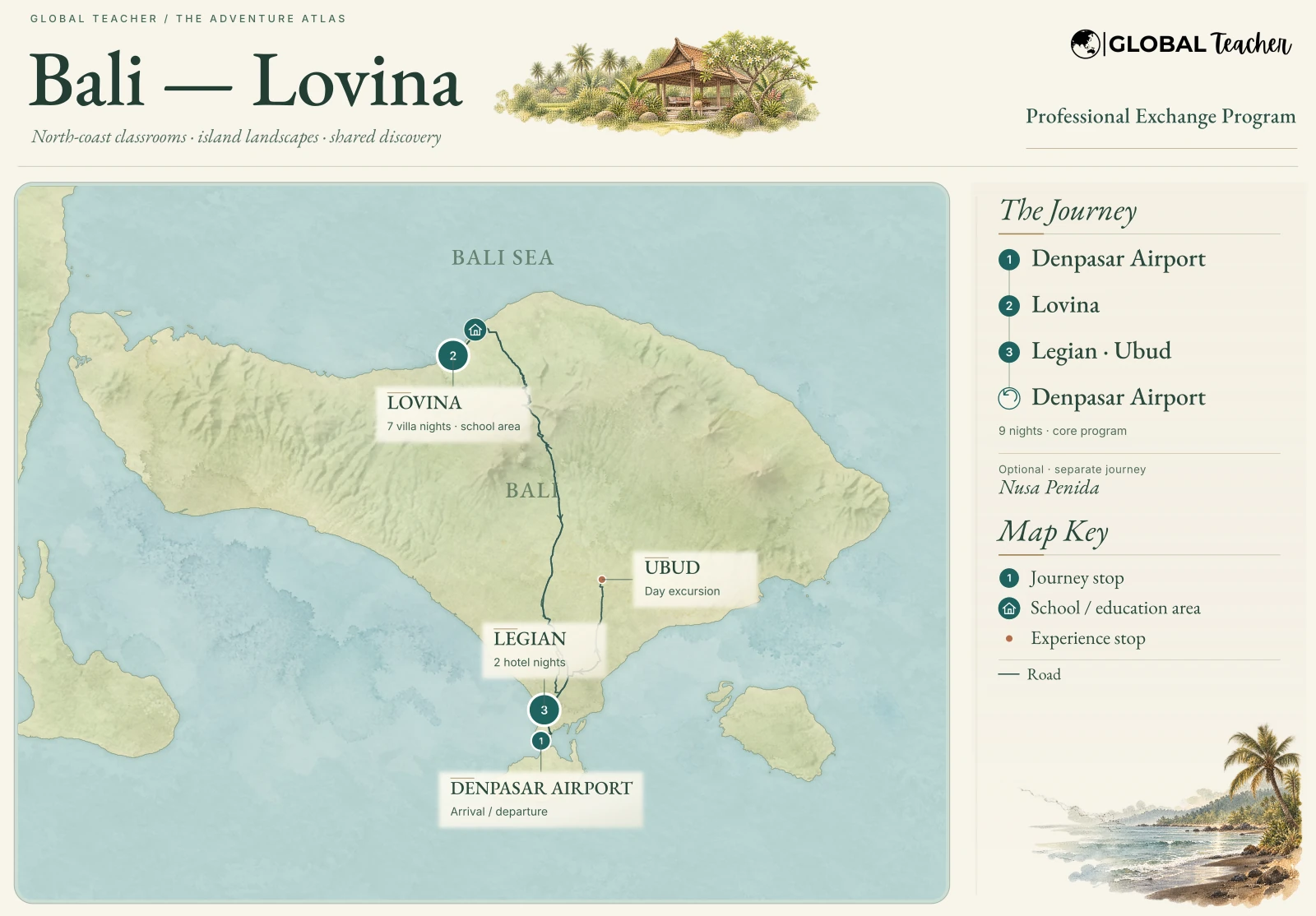 Enlarge map ↗
ⓘ Map sources
Routes are representative journey connections, not navigation tracks. Decorative washes are not bathymetry or surveyed vegetation.
Routes and mapping: OpenStreetMap contributors, ODbL 1.0. Coastlines and reference water: Natural Earth (public domain) and GSHHG by Paul Wessel & Walter H. F. Smith (GNU LGPL 3 or later), according to the per-map source register.
Place coordinates: GeoNames, CC BY 4.0, with Global Teacher program sources. Labels, selected coordinates and presentation have been adapted; sites are represented only to their verified precision.
Land relief: SRTM and GMTED data courtesy of the U.S. Geological Survey, via the Mapzen / Tilezen terrain compilation. NOAA source compilation: DOC/NOAA/NESDIS/NCEI — National Centers for Environmental Information, NESDIS, NOAA, U.S. Department of Commerce. U.S. Government material is not subject to U.S. copyright. Terrain colours and shadows are styled; no seafloor depth is illustrated. Full terrain-provider attribution.
Illustrations: independent AI-generated watercolour artwork from the approved collection, for regional atmosphere only. Decorative scenes do not identify schools, lodging, attractions or activities. Logo supplied by Global Teacher. Inter and EB Garamond: SIL Open Font License. Full provenance and licence notices are retained with the source collection.
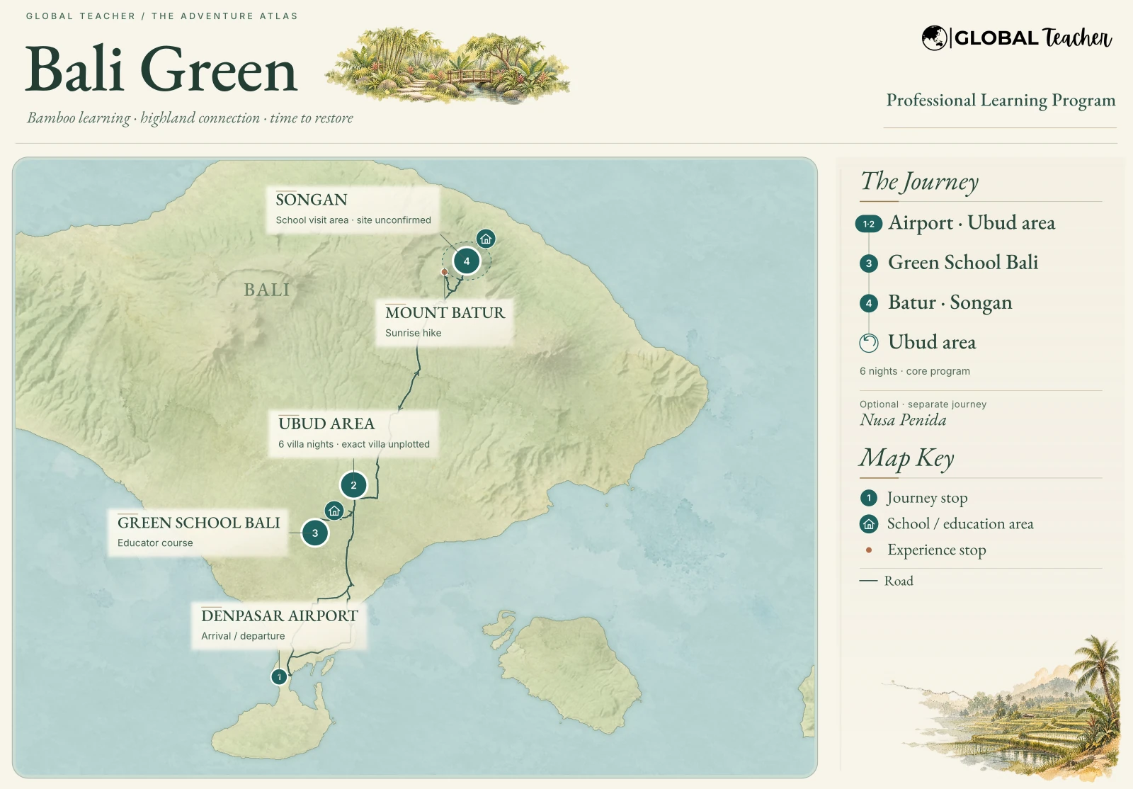 Enlarge map ↗
ⓘ Map sources
Routes are representative journey connections, not navigation tracks. Decorative washes are not bathymetry or surveyed vegetation.
Routes and mapping: OpenStreetMap contributors, ODbL 1.0. Coastlines and reference water: Natural Earth (public domain) and GSHHG by Paul Wessel & Walter H. F. Smith (GNU LGPL 3 or later), according to the per-map source register.
Place coordinates: GeoNames, CC BY 4.0, with Global Teacher program sources. Labels, selected coordinates and presentation have been adapted; sites are represented only to their verified precision.
Land relief: SRTM and GMTED data courtesy of the U.S. Geological Survey, via the Mapzen / Tilezen terrain compilation. NOAA source compilation: DOC/NOAA/NESDIS/NCEI — National Centers for Environmental Information, NESDIS, NOAA, U.S. Department of Commerce. U.S. Government material is not subject to U.S. copyright. Terrain colours and shadows are styled; no seafloor depth is illustrated. Full terrain-provider attribution.
Illustrations: independent AI-generated watercolour artwork from the approved collection, for regional atmosphere only. Decorative scenes do not identify schools, lodging, attractions or activities. Logo supplied by Global Teacher. Inter and EB Garamond: SIL Open Font License. Full provenance and licence notices are retained with the source collection.
 Enlarge map ↗
ⓘ Map sources
Routes are representative journey connections, not navigation tracks. Decorative washes are not bathymetry or surveyed vegetation.
Routes and mapping: OpenStreetMap contributors, ODbL 1.0. Coastlines and reference water: Natural Earth (public domain) and GSHHG by Paul Wessel & Walter H. F. Smith (GNU LGPL 3 or later), according to the per-map source register.
Place coordinates: GeoNames, CC BY 4.0, with Global Teacher program sources. Labels, selected coordinates and presentation have been adapted; sites are represented only to their verified precision.
Land relief: SRTM and GMTED data courtesy of the U.S. Geological Survey, via the Mapzen / Tilezen terrain compilation. NOAA source compilation: DOC/NOAA/NESDIS/NCEI — National Centers for Environmental Information, NESDIS, NOAA, U.S. Department of Commerce. U.S. Government material is not subject to U.S. copyright. Terrain colours and shadows are styled; no seafloor depth is illustrated. Full terrain-provider attribution.
Illustrations: independent AI-generated watercolour artwork from the approved collection, for regional atmosphere only. Decorative scenes do not identify schools, lodging, attractions or activities. Logo supplied by Global Teacher. Inter and EB Garamond: SIL Open Font License. Full provenance and licence notices are retained with the source collection.
 Enlarge map ↗
ⓘ Map sources
Routes are representative journey connections, not navigation tracks. Decorative washes are not bathymetry or surveyed vegetation.
Routes and mapping: OpenStreetMap contributors, ODbL 1.0. Coastlines and reference water: Natural Earth (public domain) and GSHHG by Paul Wessel & Walter H. F. Smith (GNU LGPL 3 or later), according to the per-map source register.
Place coordinates: GeoNames, CC BY 4.0, with Global Teacher program sources. Labels, selected coordinates and presentation have been adapted; sites are represented only to their verified precision.
Land relief: SRTM and GMTED data courtesy of the U.S. Geological Survey, via the Mapzen / Tilezen terrain compilation. NOAA source compilation: DOC/NOAA/NESDIS/NCEI — National Centers for Environmental Information, NESDIS, NOAA, U.S. Department of Commerce. U.S. Government material is not subject to U.S. copyright. Terrain colours and shadows are styled; no seafloor depth is illustrated. Full terrain-provider attribution.
Illustrations: independent AI-generated watercolour artwork from the approved collection, for regional atmosphere only. Decorative scenes do not identify schools, lodging, attractions or activities. Logo supplied by Global Teacher. Inter and EB Garamond: SIL Open Font License. Full provenance and licence notices are retained with the source collection.
 Enlarge map ↗
ⓘ Map sources
Routes are representative journey connections, not navigation tracks. Decorative washes are not bathymetry or surveyed vegetation.
Routes and mapping: OpenStreetMap contributors, ODbL 1.0. Coastlines and reference water: Natural Earth (public domain) and GSHHG by Paul Wessel & Walter H. F. Smith (GNU LGPL 3 or later), according to the per-map source register.
Place coordinates: GeoNames, CC BY 4.0, with Global Teacher program sources. Labels, selected coordinates and presentation have been adapted; sites are represented only to their verified precision.
Land relief: SRTM and GMTED data courtesy of the U.S. Geological Survey, via the Mapzen / Tilezen terrain compilation. NOAA source compilation: DOC/NOAA/NESDIS/NCEI — National Centers for Environmental Information, NESDIS, NOAA, U.S. Department of Commerce. U.S. Government material is not subject to U.S. copyright. Terrain colours and shadows are styled; no seafloor depth is illustrated. Full terrain-provider attribution.
Illustrations: independent AI-generated watercolour artwork from the approved collection, for regional atmosphere only. Decorative scenes do not identify schools, lodging, attractions or activities. Logo supplied by Global Teacher. Inter and EB Garamond: SIL Open Font License. Full provenance and licence notices are retained with the source collection.
 Enlarge map ↗
ⓘ Map sources
Routes are representative journey connections, not navigation tracks. Decorative washes are not bathymetry or surveyed vegetation.
Routes and mapping: OpenStreetMap contributors, ODbL 1.0. Coastlines and reference water: Natural Earth (public domain) and GSHHG by Paul Wessel & Walter H. F. Smith (GNU LGPL 3 or later), according to the per-map source register.
Place coordinates: GeoNames, CC BY 4.0, with Global Teacher program sources. Labels, selected coordinates and presentation have been adapted; sites are represented only to their verified precision.
Land relief: SRTM and GMTED data courtesy of the U.S. Geological Survey, via the Mapzen / Tilezen terrain compilation. NOAA source compilation: DOC/NOAA/NESDIS/NCEI — National Centers for Environmental Information, NESDIS, NOAA, U.S. Department of Commerce. U.S. Government material is not subject to U.S. copyright. Terrain colours and shadows are styled; no seafloor depth is illustrated. Full terrain-provider attribution.
Illustrations: independent AI-generated watercolour artwork from the approved collection, for regional atmosphere only. Decorative scenes do not identify schools, lodging, attractions or activities. Logo supplied by Global Teacher. Inter and EB Garamond: SIL Open Font License. Full provenance and licence notices are retained with the source collection.
 Enlarge map ↗
ⓘ Map sources
Routes are representative journey connections, not navigation tracks. Decorative washes are not bathymetry or surveyed vegetation.
Routes and mapping: OpenStreetMap contributors, ODbL 1.0. Coastlines and reference water: Natural Earth (public domain) and GSHHG by Paul Wessel & Walter H. F. Smith (GNU LGPL 3 or later), according to the per-map source register.
Place coordinates: GeoNames, CC BY 4.0, with Global Teacher program sources. Labels, selected coordinates and presentation have been adapted; sites are represented only to their verified precision.
Land relief: SRTM and GMTED data courtesy of the U.S. Geological Survey, via the Mapzen / Tilezen terrain compilation. NOAA source compilation: DOC/NOAA/NESDIS/NCEI — National Centers for Environmental Information, NESDIS, NOAA, U.S. Department of Commerce. U.S. Government material is not subject to U.S. copyright. Terrain colours and shadows are styled; no seafloor depth is illustrated. Full terrain-provider attribution.
Illustrations: independent AI-generated watercolour artwork from the approved collection, for regional atmosphere only. Decorative scenes do not identify schools, lodging, attractions or activities. Logo supplied by Global Teacher. Inter and EB Garamond: SIL Open Font License. Full provenance and licence notices are retained with the source collection.
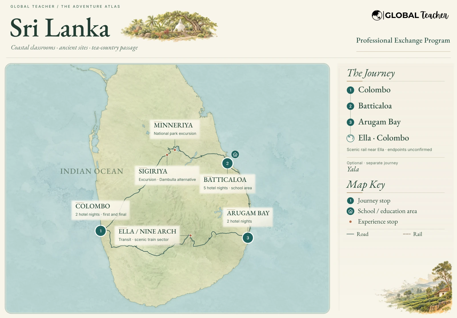 Enlarge map ↗
ⓘ Map sources
Routes are representative journey connections, not navigation tracks. Decorative washes are not bathymetry or surveyed vegetation.
Routes and mapping: OpenStreetMap contributors, ODbL 1.0. Coastlines and reference water: Natural Earth (public domain) and GSHHG by Paul Wessel & Walter H. F. Smith (GNU LGPL 3 or later), according to the per-map source register.
Place coordinates: GeoNames, CC BY 4.0, with Global Teacher program sources. Labels, selected coordinates and presentation have been adapted; sites are represented only to their verified precision.
Land relief: SRTM and GMTED data courtesy of the U.S. Geological Survey, via the Mapzen / Tilezen terrain compilation. NOAA source compilation: DOC/NOAA/NESDIS/NCEI — National Centers for Environmental Information, NESDIS, NOAA, U.S. Department of Commerce. U.S. Government material is not subject to U.S. copyright. Terrain colours and shadows are styled; no seafloor depth is illustrated. Full terrain-provider attribution.
Illustrations: independent AI-generated watercolour artwork from the approved collection, for regional atmosphere only. Decorative scenes do not identify schools, lodging, attractions or activities. Logo supplied by Global Teacher. Inter and EB Garamond: SIL Open Font License. Full provenance and licence notices are retained with the source collection.
 Enlarge map ↗
ⓘ Map sources
Routes are representative journey connections, not navigation tracks. Decorative washes are not bathymetry or surveyed vegetation.
Routes and mapping: OpenStreetMap contributors, ODbL 1.0. Coastlines and reference water: Natural Earth (public domain) and GSHHG by Paul Wessel & Walter H. F. Smith (GNU LGPL 3 or later), according to the per-map source register.
Place coordinates: GeoNames, CC BY 4.0, with Global Teacher program sources. Labels, selected coordinates and presentation have been adapted; sites are represented only to their verified precision.
Land relief: SRTM and GMTED data courtesy of the U.S. Geological Survey, via the Mapzen / Tilezen terrain compilation. NOAA source compilation: DOC/NOAA/NESDIS/NCEI — National Centers for Environmental Information, NESDIS, NOAA, U.S. Department of Commerce. U.S. Government material is not subject to U.S. copyright. Terrain colours and shadows are styled; no seafloor depth is illustrated. Full terrain-provider attribution.
Illustrations: independent AI-generated watercolour artwork from the approved collection, for regional atmosphere only. Decorative scenes do not identify schools, lodging, attractions or activities. Logo supplied by Global Teacher. Inter and EB Garamond: SIL Open Font License. Full provenance and licence notices are retained with the source collection.
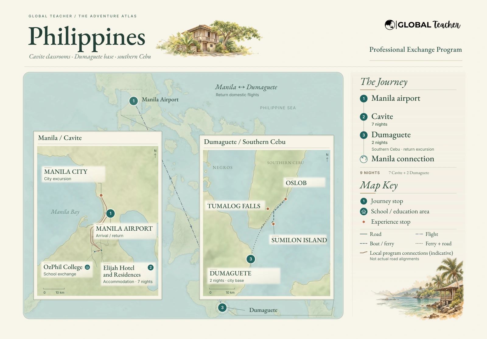 Enlarge map ↗
ⓘ Map sources
Routes are representative journey connections, not navigation tracks. Decorative washes are not bathymetry or surveyed vegetation.
Routes and mapping: OpenStreetMap contributors, ODbL 1.0. Coastlines and reference water: Natural Earth (public domain) and GSHHG by Paul Wessel & Walter H. F. Smith (GNU LGPL 3 or later), according to the per-map source register.
Place coordinates: GeoNames, CC BY 4.0, with Global Teacher program sources. Labels, selected coordinates and presentation have been adapted; sites are represented only to their verified precision.
Land relief: SRTM and GMTED data courtesy of the U.S. Geological Survey, via the Mapzen / Tilezen terrain compilation. NOAA source compilation: DOC/NOAA/NESDIS/NCEI — National Centers for Environmental Information, NESDIS, NOAA, U.S. Department of Commerce. U.S. Government material is not subject to U.S. copyright. Terrain colours and shadows are styled; no seafloor depth is illustrated. Full terrain-provider attribution.
Illustrations: independent AI-generated watercolour artwork from the approved collection, for regional atmosphere only. Decorative scenes do not identify schools, lodging, attractions or activities. Logo supplied by Global Teacher. Inter and EB Garamond: SIL Open Font License. Full provenance and licence notices are retained with the source collection.
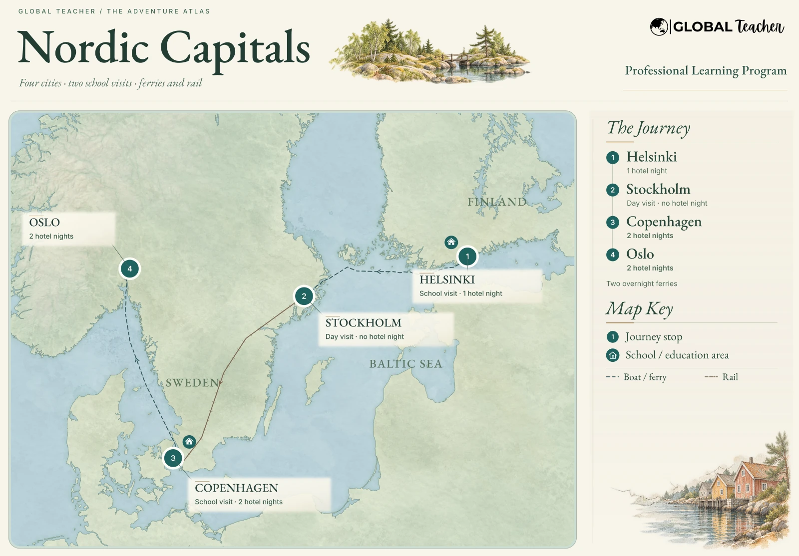 Enlarge map ↗
ⓘ Map sources
Routes are representative journey connections, not navigation tracks. Decorative washes are not bathymetry or surveyed vegetation.
Routes and mapping: OpenStreetMap contributors, ODbL 1.0. Coastlines and reference water: Natural Earth (public domain) and GSHHG by Paul Wessel & Walter H. F. Smith (GNU LGPL 3 or later), according to the per-map source register.
Place coordinates: GeoNames, CC BY 4.0, with Global Teacher program sources. Labels, selected coordinates and presentation have been adapted; sites are represented only to their verified precision.
Land relief: SRTM and GMTED data courtesy of the U.S. Geological Survey, via the Mapzen / Tilezen terrain compilation. NOAA source compilation: DOC/NOAA/NESDIS/NCEI — National Centers for Environmental Information, NESDIS, NOAA, U.S. Department of Commerce. U.S. Government material is not subject to U.S. copyright. Terrain colours and shadows are styled; no seafloor depth is illustrated. Full terrain-provider attribution.
Illustrations: independent AI-generated watercolour artwork from the approved collection, for regional atmosphere only. Decorative scenes do not identify schools, lodging, attractions or activities. Logo supplied by Global Teacher. Inter and EB Garamond: SIL Open Font License. Full provenance and licence notices are retained with the source collection.
 Enlarge map ↗
ⓘ Map sources
Routes are representative journey connections, not navigation tracks. Decorative washes are not bathymetry or surveyed vegetation.
Routes and mapping: OpenStreetMap contributors, ODbL 1.0. Coastlines and reference water: Natural Earth (public domain) and GSHHG by Paul Wessel & Walter H. F. Smith (GNU LGPL 3 or later), according to the per-map source register.
Place coordinates: GeoNames, CC BY 4.0, with Global Teacher program sources. Labels, selected coordinates and presentation have been adapted; sites are represented only to their verified precision.
Land relief: SRTM and GMTED data courtesy of the U.S. Geological Survey, via the Mapzen / Tilezen terrain compilation. NOAA source compilation: DOC/NOAA/NESDIS/NCEI — National Centers for Environmental Information, NESDIS, NOAA, U.S. Department of Commerce. U.S. Government material is not subject to U.S. copyright. Terrain colours and shadows are styled; no seafloor depth is illustrated. Full terrain-provider attribution.
Illustrations: independent AI-generated watercolour artwork from the approved collection, for regional atmosphere only. Decorative scenes do not identify schools, lodging, attractions or activities. Logo supplied by Global Teacher. Inter and EB Garamond: SIL Open Font License. Full provenance and licence notices are retained with the source collection.
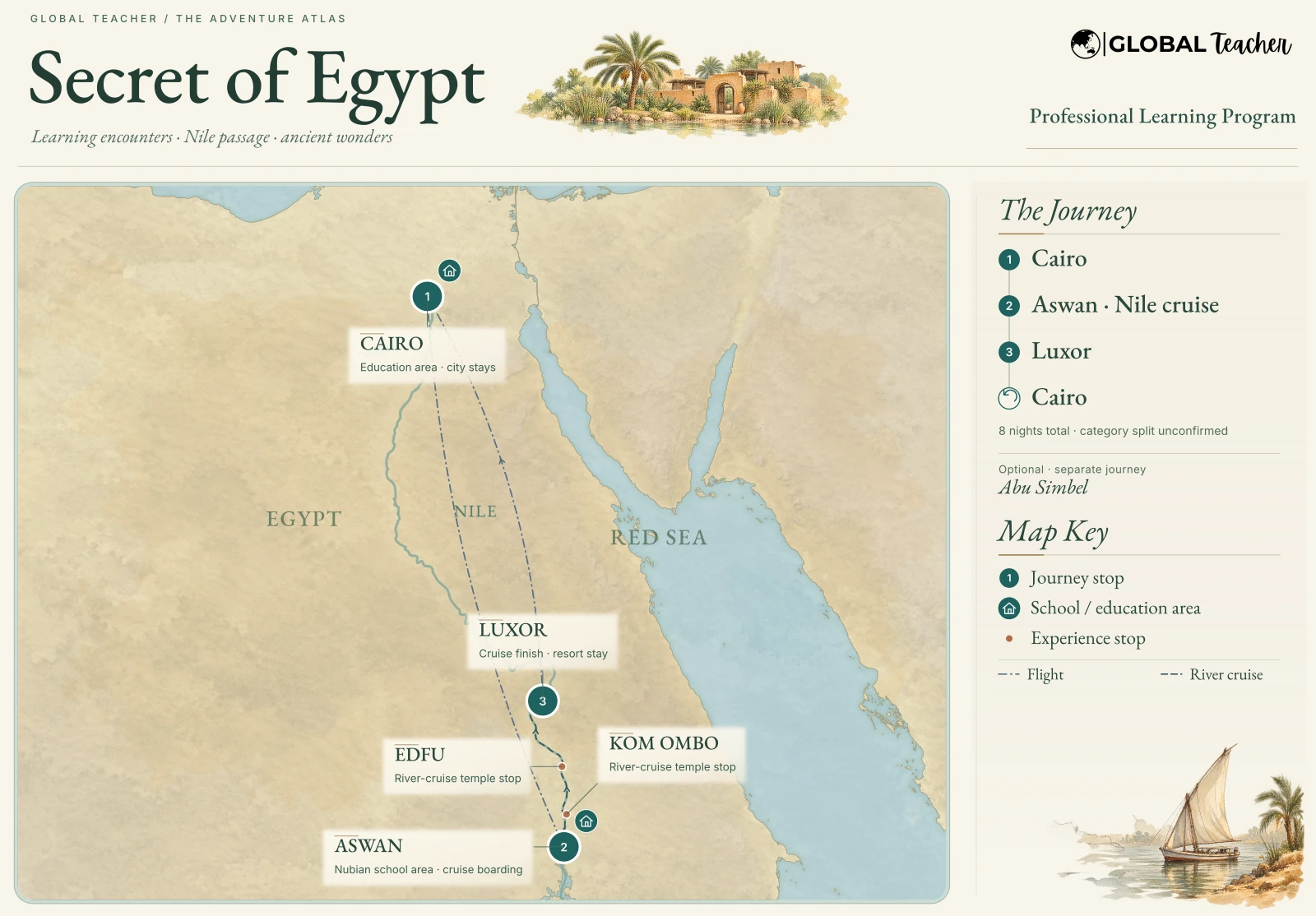 Enlarge map ↗
ⓘ Map sources
Routes are representative journey connections, not navigation tracks. Decorative washes are not bathymetry or surveyed vegetation.
Routes and mapping: OpenStreetMap contributors, ODbL 1.0. Coastlines and reference water: Natural Earth (public domain) and GSHHG by Paul Wessel & Walter H. F. Smith (GNU LGPL 3 or later), according to the per-map source register.
Place coordinates: GeoNames, CC BY 4.0, with Global Teacher program sources. Labels, selected coordinates and presentation have been adapted; sites are represented only to their verified precision.
Land relief: SRTM and GMTED data courtesy of the U.S. Geological Survey, via the Mapzen / Tilezen terrain compilation. NOAA source compilation: DOC/NOAA/NESDIS/NCEI — National Centers for Environmental Information, NESDIS, NOAA, U.S. Department of Commerce. U.S. Government material is not subject to U.S. copyright. Terrain colours and shadows are styled; no seafloor depth is illustrated. Full terrain-provider attribution.
Illustrations: independent AI-generated watercolour artwork from the approved collection, for regional atmosphere only. Decorative scenes do not identify schools, lodging, attractions or activities. Logo supplied by Global Teacher. Inter and EB Garamond: SIL Open Font License. Full provenance and licence notices are retained with the source collection.